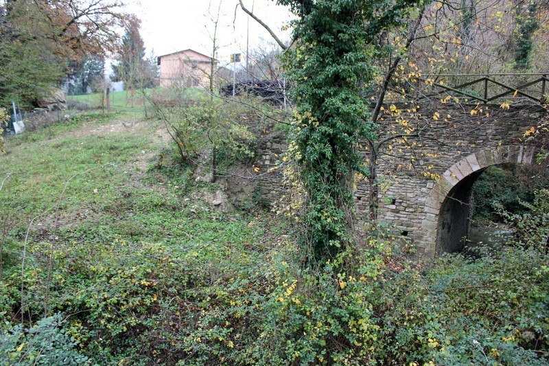
Labaro Bridge on the Via Flaminia

Latitude:  41°59'14.04"N
Longitude:  12°29'39.42"E
elev 84 ft.

Our destination on this very rainy Italian day was Prima Porta, to see La Villa di Livia.  We rode the train from Piazza del Popolo north along side the Flamina to the Montebello train stop.  As we rode the train through Labaro I just happened to look out the window (this is never easy on Italian trains due to the extensive graffiti) and spot what looked like a Roman bridge tucked in between the tracks, a massive overpass and the new Flaminia.  I quickly wrote down the name of the closest stop, La Celsa, and tried to guess the distance from the stop.  We continued to Livia's, which turned out to be closed, then on to Malborghetto where we opted to head back to Rome instead of becoming soaked by the constant rain.


Still having some time on our ticket we decided to see if we could find the bridge. 


We emerged from the train station into a busy intersection, headed south under the overpass towards an outdoor produce stand and some parked cars.  If you study the aerial photo below, you'll see the blue marker that locates the bridge.  That small white section is what remains of the Flaminia Antica in Labaro.  It's hard to tell where the ancient road went both north and south of the bridge.


It most likely runs right underneath the photo below.


Through a fence and a lot of underbrush, I spotted the top of the bridge.


I haven't been able to find the name of this bridge.  There are a few photographs of it on the web, but no additional information other than a reference to both Etruscan and Roman design.


The photo below is taken from the southern side of the bridge looking back towards the train station.


I tried to find a way to climb down into the river bed, but access was impossible.


The bridge has clearly been restored, but only to preserve it, not for either travel or tourism.  You can see that the surrounding concrete both protects it an isolates it.


Finding this bridge was a complete surprise.  From what I could tell, the simple structure of the Roman arch was completely intact.  The contrast between the arch's raw material, it's slightly organic form with the surrounding chaos was fantastic.

Directions 


View Labaro Roman Bridge in a larger map

Carsulae on the Via Flaminia

Latitude:  42°38'21.20"N
Longitude:  12°33'32.71"E
elev 1460 ft.


Carsulae is an outstanding excavation of a once thriving city located on the ancient Via Flaminia.  It was built sometime around 220 BC, and was likely a rest stop for people traveling along the Flaminia. The site is situated in a magnificent location among rolling hills and small mountains, about 40 miles north of Terni. 


 It was abandoned sometime around the third century, and initially excavated in the 1850's, with more extensive excavations starting in the 1950's.  On the map below, you can see the location of Carsulae on the Flaminia.

Source: http://en.wikipedia.org/wiki/Via_Flaminia

My initial research of Roman Roads took place back in the States. At one point I came across a photograph of an impressive arch on the Wikipedia website.

Source: http://en.wikipedia.org/wiki/Carsulae
I don't think there is any one specific way of finding a Roman Road.   I generally started by searching for old maps, which inevitably lead me to photographs, which in turn lead me to specific sites.  If I found an image that captivated me, then I dug in a little deeper and tried to find the location.  So it was this photograph that led me to Carsulae, one of the most magical places I've visited.
The trip to Carsulae started from our base in Umbertide.  Generally, it would take me a whole day to plot out the route to our destination.  I was traveling by public transportation so a lot of time was spent reading through train and bus schedules.  Remote locations often only had a few buses a day that ran to and from major cities.  I'd already been stranded a few times and didn't enjoy it.  Additionally, the last train of the day returning to Umbertide left Perugia at 7:00 PM.  This meant that wherever I was, I had to get back to Perugia in time to catch that train.   Once I had all the schedules and maps saved them on my flash drive, I would head to the local print shop in Umbertide, print them out, sort them, and place them in a folder that I'd travel with.

The trip to Carsulae took between 3 and 4 hours.  This meant that we traveled roughly 7 hours that day, allowing about 2 hours at the site before starting the trek back.  We took the train to Perugia Santa Anna, switched and took another train to Terni and caught a bus from Terni to Pozzo Azzuano.  I had mapped out a 2 kilometer walk from the final bus stop to the site, but it turned out that the very courteous bus driver let us off directly across from the excavation.


When I arrived at Carsulae, I found the Flaminia and started a slow, studious journey through the town.


Initially I headed to the south looking for an end of the Flaminia.

At the southernmost end of town, the Flaminia disapeared beneath 4 to 5 feet of topsoil.  This revealed both the extent of the excavation as well as the changes that had taken place in the landscape over the last 2000 years.


I turned and headed north to the other
end of the road.
The pavers were made from a softer more porous stone, a material I hadn't come across yet, clearly an indigenous rock to the area.  There were excellent examples of borders, wear marks and a gutter system.


The road passed through the central part of town where an arch marked an entrance to what was once an extensive structure.


In the photograph below you can see the grass growing in the wear marks, as well as a variety of different sized pavers.


As I followed the road up a small hill, I saw the arch in the distance.  It was a beautiful day, robust clouds, and a gentle wind.  The excavation was empty, except for my Janet who had headed into the woods to find images in the bark of trees (check out her website and this will make more sense (Wood Interpretation Society).  I proceeded very slowly toward the arch trying to understand everything that was going on around me.


In the next 4 pictures you can see details of my approach to the arch.  Originally named the Arch of Trajan and currently referred to as the Arco di San Damiano, the arch, that marked the early entrance to the city.  Though all of the original marble had been removed, and most of it's surrounding structures fallen, I was struck by both it's simplicity and massive weight.


The excavation of the Flaminia ended another 100 yards to the north, a little beyond the mausoleum below.


Pontericciolo on the Via Flaminia

The Via Flaminia 

The Via Flaminia was an important road the went from Rome northeast to the coastal town of Ariminum or the modern Rimini. As you can see in the two maps below a secondary route was created between Narni, through Spoletto, back to the original road.


Source: http://en.wikipedia.org/wiki/Via_Flaminia

Source: http://es.wikipedia.org/wiki/Archivo:Via_Flaminia_map.jpg

The area of the Flaminia that we explored on this day was just over the border of Umbria in the region of Le Marche.  The Journey was lead by our good friend, and fellow road hunter, Karen  Fronduti.  Following a tip from Bill Thayer's website, where he describes 4 bridges in this area of Marche, we drove well into the mountains north of Gubbio.

Directions


View Pontericciolo Bridges in a larger map
Bridge #1

Latitude:  43°26'17.89"N
Longitude:  12°37'56.44"E
elev 1341 ft.

If you can get to the little town of Pontericciolo and head south on SP3 (also SS3) after a short distance you'll come to a sign pointing towards the Area Archeologica to the right.  After passing a small group of houses on the left, you'll find a good place to park and will be close to the first bridge.


Parking space

The first bridge is clearly marked with a sign that says Divieto Di Scarico, meaning dumping prohibited.


This is a classic two arch Roman bridge.  The river bed had been cleared since Bill Thayer's visit.  It was a little slippery getting down to the river, but worth the trip. The large stones were wonderfully shaped and holding together well.  It was nice to see  the Flaminia crossing such a beautiful form.


The Flaminia continues to the south from the first bridge.  The road remains paved until just before the second bridge.


Bridge #2

Latitude:  43°26'2.81"N
Longitude:  12°37'57.27"E
elev  1472 ft.

Other than what Bill Thayer has written about these bridges, I haven't been able to find any other information on them.  The second bridge has been restored several times and was under construction when Thayer visited it in 2000.


Apparently somewhere under all of this modern(ish) stone is a Roman Foundation.


Viadotto Romano di Cantiano #3

Latitude:  43°25'59.10"N
Longitude:  12°38'4.01"E
elev1500 ft.

As we approached the third bridge we could see the new Flaminia across the valley.


As we approached the bridge, a section of the Ancient Flaminia appeared on the left of the trail emerging from the hillside.


It looked like the ancient pavers had been replaced with a brick surface at some point in time.


Standing in the center of the flaminia, I shot this picture hoping that I could see how the direction of the road lined up with the higher version.  I'd guess that a considerable amount of soil had washed down the hillside and covered up sections of the original road.


The bridge itself appeared to have the larger Roman stones towards the bottom.


There were two of the basins, both on the southern side of the bridge.  I'm guessing that they served as retaining walls that filtered the mud from the soil as it washed down the hill.


This view is looking through the bridge into the catch basin.


I found this section of the Flaminia to be quite honest.  It was a beautiful walk through the countryside on a well used farm road.   


Bridge #4

Latitude:  43°25'55.04"N
Longitude:  12°38'16.93"E
elev 1555 ft.

Heading further along the Flaminia, we eventually came to the 4th bridge. 


It's easy to miss, particularly if you're looking for something Roman.  It has been completely restored leaving no traces of Roman engineering.


The dense ground cover made it very difficult to navigate around the base of the bridge.  Bill Thayer actually reflects on walking over the bridge without noticing it.  Regardless, the juxtaposition of the stone and the brambles is always spectacular.


Ponte Mallio - Cagli

Latitude:  43°33'3.35"N
Longitude:  12°39'3.46"E
elev 798 ft.

We took a short drive from Pontericcio north to Cagli to see another bridge identified by Bill Thayer.  Below are a few Google Earth images of what it looks like to approach this bridge on the new Flaminia.  To the left of this intersection is a gas station where we stopped to ask the location of the ancient bridge.  A young Italian man, eager to practice his English, sent us over the the new bridge.


About half way across the bridge we spotted the Ponte Mallio off to the left.


This is a nice photo from the Wikipedia page that shows as much of the bridge that you can see from any one point.


If you take a quick left after you pass over the new bridge you can actually drive directly onto the Ponte Mallio.  Apparently it was rugged enough during World War II that tanks drove over it.


There's a path that leads down to the swampy area at the base of the bridge.


It was a very rainy day when we visited the Ponte Mallio.  This made walking through the long grass particularly unpleasant, though the view from directly in front of the Roman arch was well worth it.


I love this view of the ancient bridge and the new one converging on the horizon.


Directions


View Viadatto Romana di Cantano in a larger map