The Via Flaminia
The Via Flaminia was an important road the went from Rome northeast to the coastal town of Ariminum or the modern Rimini. As you can see in the two maps below a secondary route was created between Narni, through Spoletto, back to the original road.
The area of the Flaminia that we explored on this day was just over the border of Umbria in the region of Le Marche. The Journey was lead by our good friend, and fellow road hunter, Karen Fronduti. Following a tip from Bill Thayer's website, where he describes 4 bridges in this area of Marche, we drove well into the mountains north of Gubbio.
Directions
View Pontericciolo Bridges in a larger map
Bridge #1
Latitude: 43°26'17.89"N
Longitude: 12°37'56.44"E
elev 1341 ft.
If you can get to the little town of Pontericciolo and head south on SP3 (also SS3) after a short distance you'll come to a sign pointing towards the Area Archeologica to the right. After passing a small group of houses on the left, you'll find a good place to park and will be close to the first bridge.
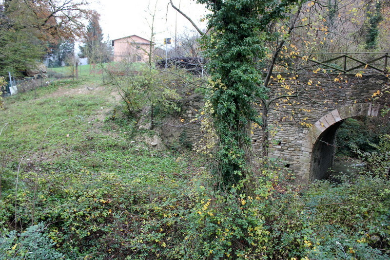
The first bridge is clearly marked with a sign that says Divieto Di Scarico, meaning dumping prohibited.

This is a classic two arch Roman bridge. The river bed had been cleared since Bill Thayer's visit. It was a little slippery getting down to the river, but worth the trip. The large stones were wonderfully shaped and holding together well. It was nice to see the Flaminia crossing such a beautiful form.

The Flaminia continues to the south from the first bridge. The road remains paved until just before the second bridge.

Bridge #2
Latitude: 43°26'2.81"N
Longitude: 12°37'57.27"E
elev 1472 ft.
Other than what Bill Thayer has written about these bridges, I haven't been able to find any other information on them. The second bridge has been restored several times and was under construction when Thayer visited it in 2000.

Apparently somewhere under all of this modern(ish) stone is a Roman Foundation.


Viadotto Romano di Cantiano #3
Latitude: 43°25'59.10"N
Longitude: 12°38'4.01"E
elev1500 ft.
As we approached the third bridge we could see the new Flaminia across the valley.

As we approached the bridge, a section of the Ancient Flaminia appeared on the left of the trail emerging from the hillside.


It looked like the ancient pavers had been replaced with a brick surface at some point in time.

Standing in the center of the flaminia, I shot this picture hoping that I could see how the direction of the road lined up with the higher version. I'd guess that a considerable amount of soil had washed down the hillside and covered up sections of the original road.

The bridge itself appeared to have the larger Roman stones towards the bottom.

There were two of the basins, both on the southern side of the bridge. I'm guessing that they served as retaining walls that filtered the mud from the soil as it washed down the hill.

This view is looking through the bridge into the catch basin.


I found this section of the Flaminia to be quite honest. It was a beautiful walk through the countryside on a well used farm road.

Bridge #4
Latitude: 43°25'55.04"N
Longitude: 12°38'16.93"E
elev 1555 ft.
Heading further along the Flaminia, we eventually came to the 4th bridge.

It's easy to miss, particularly if you're looking for something Roman. It has been completely restored leaving no traces of Roman engineering.

The dense ground cover made it very difficult to navigate around the base of the bridge. Bill Thayer actually reflects on walking over the bridge without noticing it. Regardless, the juxtaposition of the stone and the brambles is always spectacular.

Ponte Mallio - Cagli
Latitude: 43°33'3.35"N
Longitude: 12°39'3.46"E
elev 798 ft.
We took a short drive from Pontericcio north to Cagli to see another bridge identified by Bill Thayer. Below are a few Google Earth images of what it looks like to approach this bridge on the new Flaminia. To the left of this intersection is a gas station where we stopped to ask the location of the ancient bridge. A young Italian man, eager to practice his English, sent us over the the new bridge.

About half way across the bridge we spotted the Ponte Mallio off to the left.


This is a nice photo from the Wikipedia page that shows as much of the bridge that you can see from any one point.

If you take a quick left after you pass over the new bridge you can actually drive directly onto the Ponte Mallio. Apparently it was rugged enough during World War II that tanks drove over it.

There's a path that leads down to the swampy area at the base of the bridge.

It was a very rainy day when we visited the Ponte Mallio. This made walking through the long grass particularly unpleasant, though the view from directly in front of the Roman arch was well worth it.


I love this view of the ancient bridge and the new one converging on the horizon.


Directions
View Viadatto Romana di Cantano in a larger map
The Via Flaminia was an important road the went from Rome northeast to the coastal town of Ariminum or the modern Rimini. As you can see in the two maps below a secondary route was created between Narni, through Spoletto, back to the original road.
 |
| Source: http://en.wikipedia.org/wiki/Via_Flaminia |
 |
| Source: http://es.wikipedia.org/wiki/Archivo:Via_Flaminia_map.jpg |
The area of the Flaminia that we explored on this day was just over the border of Umbria in the region of Le Marche. The Journey was lead by our good friend, and fellow road hunter, Karen Fronduti. Following a tip from Bill Thayer's website, where he describes 4 bridges in this area of Marche, we drove well into the mountains north of Gubbio.
Directions
View Pontericciolo Bridges in a larger map
Bridge #1
Latitude: 43°26'17.89"N
Longitude: 12°37'56.44"E
elev 1341 ft.
If you can get to the little town of Pontericciolo and head south on SP3 (also SS3) after a short distance you'll come to a sign pointing towards the Area Archeologica to the right. After passing a small group of houses on the left, you'll find a good place to park and will be close to the first bridge.

 |
| Parking space |
The first bridge is clearly marked with a sign that says Divieto Di Scarico, meaning dumping prohibited.

This is a classic two arch Roman bridge. The river bed had been cleared since Bill Thayer's visit. It was a little slippery getting down to the river, but worth the trip. The large stones were wonderfully shaped and holding together well. It was nice to see the Flaminia crossing such a beautiful form.

Bridge #2
Latitude: 43°26'2.81"N
Longitude: 12°37'57.27"E
elev 1472 ft.
Other than what Bill Thayer has written about these bridges, I haven't been able to find any other information on them. The second bridge has been restored several times and was under construction when Thayer visited it in 2000.

Apparently somewhere under all of this modern(ish) stone is a Roman Foundation.


Viadotto Romano di Cantiano #3
Latitude: 43°25'59.10"N
Longitude: 12°38'4.01"E
elev1500 ft.
As we approached the third bridge we could see the new Flaminia across the valley.

As we approached the bridge, a section of the Ancient Flaminia appeared on the left of the trail emerging from the hillside.


It looked like the ancient pavers had been replaced with a brick surface at some point in time.

Standing in the center of the flaminia, I shot this picture hoping that I could see how the direction of the road lined up with the higher version. I'd guess that a considerable amount of soil had washed down the hillside and covered up sections of the original road.

The bridge itself appeared to have the larger Roman stones towards the bottom.

There were two of the basins, both on the southern side of the bridge. I'm guessing that they served as retaining walls that filtered the mud from the soil as it washed down the hill.

This view is looking through the bridge into the catch basin.


I found this section of the Flaminia to be quite honest. It was a beautiful walk through the countryside on a well used farm road.

Bridge #4
Latitude: 43°25'55.04"N
Longitude: 12°38'16.93"E
elev 1555 ft.
Heading further along the Flaminia, we eventually came to the 4th bridge.

It's easy to miss, particularly if you're looking for something Roman. It has been completely restored leaving no traces of Roman engineering.
The dense ground cover made it very difficult to navigate around the base of the bridge. Bill Thayer actually reflects on walking over the bridge without noticing it. Regardless, the juxtaposition of the stone and the brambles is always spectacular.

Ponte Mallio - Cagli
Latitude: 43°33'3.35"N
Longitude: 12°39'3.46"E
elev 798 ft.
We took a short drive from Pontericcio north to Cagli to see another bridge identified by Bill Thayer. Below are a few Google Earth images of what it looks like to approach this bridge on the new Flaminia. To the left of this intersection is a gas station where we stopped to ask the location of the ancient bridge. A young Italian man, eager to practice his English, sent us over the the new bridge.

About half way across the bridge we spotted the Ponte Mallio off to the left.


This is a nice photo from the Wikipedia page that shows as much of the bridge that you can see from any one point.

If you take a quick left after you pass over the new bridge you can actually drive directly onto the Ponte Mallio. Apparently it was rugged enough during World War II that tanks drove over it.

There's a path that leads down to the swampy area at the base of the bridge.

It was a very rainy day when we visited the Ponte Mallio. This made walking through the long grass particularly unpleasant, though the view from directly in front of the Roman arch was well worth it.


I love this view of the ancient bridge and the new one converging on the horizon.


View Viadatto Romana di Cantano in a larger map
No comments:
Post a Comment