Introduction

In the Fall of 2012, I spent 2 months in Italy searching for Roman Roads.   I began this project over a year earlier when I was invited by a colleague to create several maps of Marcus Aurelius' Roman Empire for a publication.  I became intrigued with the widespread  network of Roman Roads, as they spread through Europe, North Africa and into the Middle East.


Source: http://en.wikipedia.org/wiki/File:Roman_Empire_125.png
I have spent 30 years making art about my immersion into historic inquiry.  While developing the maps of the Roman Empire, I became fascinated with the idea that I could find a location on an ancient road that would reveal a very abstract sensation that identified a point in time lodged between history and future.  So I set out to find that spot.

Genius Loci is a Roman concept that that has been adapted to various contemporary disciplines such as art, architecture and landscape design.  It literally translates as "the protective spirit of a place".  Many books and articles have been written on the concept.  The Environmental and Architectural Phenomenology Newsletter has some very good articles on the subject.  My goal was to find places that were so steeped in history that even with the absence of a typical monument (house, tomb, castle, coliseum, etc..)  I would still feel a connection to it's history.  My intention was to use this research as the catalyst for my next body of work.

With this information in hand, my journey began.  As I continued to research and search for the Ancient Roman Roads from the states, I simultaneously began to collect and study the 1800's maps of Vermont near where my summer studio is located. By overlaying these old maps on top of modern maps and Google Earth images, as well as studying archival photographs of the area I found I could locate cellar holes, lost roads and the locations of long gone buildings.  Once I felt I had the location identified I would set out on my mountain bike to find and photograph these spots.

Below is a map that identified many of the early homesteads in the area, as well as the path of the railroad and the locations of the stations and flagstops.
 

This photo below shows the current landscape.
 
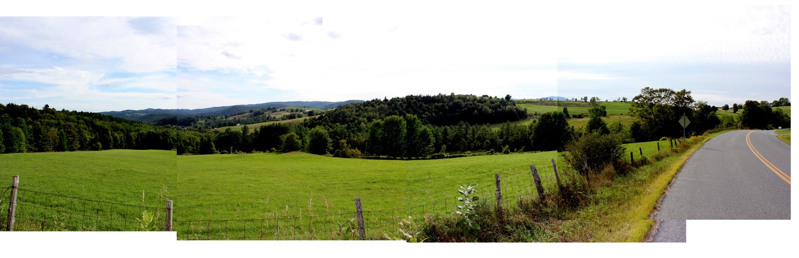
The above panorama is a rest stop on one of my excursions.
The photograph below is a train station that once sat on the Wells River/Montpelier line.  Note the barren landscape.  Most of this region was cleared of virgin forest.


Here is what remains of the station.


On the left below is a photograph of a flag stop active in the late 1800's.  The photo on the right shows the current site, identified by the large bolder behind station.


The photograph below is a cellar hole near Etna, NH that I was led to by 2 friends.  Throughout the woods surrounding the foundation we found several other foundations, probably barns, 2 wells and several stone walls that were animal pens and pastures.  This must have been a stately homestead in it's day.


Though my final goal was to generate a body of digital drawings, while still in Vermont, I experimented with various traditional drawing techniques that I hoped would capture the essence of both the process and the visceral quality of these journeys.


Porto Traiano

Latitude:  41°46'34.15"N
Longitude:  12°15'38.77"E
elev 40 ft.

The journey to Porto Traiano was my first attempt to find an ancient Roman Road.  Throughout all of my research, it often felt that I was on the verge of an original discovery, though I would soon discover that, generally, volumes of research had been done on the exact things I was studying.

While still working out of my studio in Vermont, I started to locate the important Roman Roads that connected Rome to the original ports Porto Claudio and Ostia Antica.  Having located both the ancient and the modern Via Portuensis on several maps, I decided this would be a good road to explore, hoping to find the intersection of the ancient road and the new road.  

While studying the two maps below, I noticed the hexagonal lake near the coast.  This appeared on every ancient map that I found, often varying distances from the shore line.

Source: http://www.ostia-antica.org/intro.htm

Source: http://www.ostia-antica.org/intro.htm


I opened up Google Earth and zeroed in on the location.  The same hexagonal lake still existed, though now several hundred meters from Fumicino Airport.  In a fury I started searching for information and images of what turned out to be the very important and grand port, Porto Traiano.


I found the photograph below, that showed both the perfection of the shore line and evidence of a current excavation that was underway.

Virutal Globe Trotting has a wonderful view of the current site that allows you to zoom and pan with great clarity.

Below is a quote from the Wikipedia site that describes both the Porto Claudio and the Porto Traiano, as well as the Via Portuensis.

Rome's original harbour was Ostia. Claudius constructed the first harbour on the Portus site, 4 km (2.5 mi) north of Ostia, enclosing an area of 69 hectares (170 acres), with two long curving moles projecting into the sea, and an artificial island, bearing a lighthouse, in the centre of the space between them. The foundation of this lighthouse was provided by filling one of the massive Obelisk ships, used to transport an obelisk from Egypt to adorn the spina of Vatican Circus, built during the reign of Caligula. The harbour thus opened directly to the sea on the north-west and communicated with the Tiber by a channel on the south-east. The object was to obtain protection from the prevalent south-west wind, to which the river mouth was exposed. Though Claudius, in the inscription which he caused to be erected in A.D. 46, boasted that he had freed the city of Rome from the danger of inundation, his work was only partially successful: in 62 AD Tacitus speaks of a number of grain ships sinking within the harbour during a violent storm. Nero gave the harbour the name of "Portus Augusti".

It was probably Claudius who constructed the new direct road from Rome to Portus, the Via Portuensis which was 24 km (15 mi) long. The Via Portuensis ran over the hills as far as the modern Ponte Galeria, and then straight across the plain. An older road, the Via Campana, ran along the foot of the hills, following the right bank of the Tiber, and passing the grove of the Arval Brothers at the sixth mile, to the Campus salinarum romanarum, the saltmarsh on the right bank from which it derived its name.
 
In 103 AD Trajan constructed another harbour farther inland—a hexagonal basin enclosing an area of 39 hectares (97 acres), and communicating by canals with the harbour of Claudius, with the Tiber direct, and with the sea, the last now forming the navigable arm of the Tiber (reopened for traffic by Gregory XIII and again by Paul V). It bore the name Fossa trajana, though its origin is undoubtedly due to Claudius. The basin itself is still preserved, and is now a reedy lagoon. It was surrounded by extensive warehouses, remains of which may still be seen: the fineness of the brickwork of which they are built is remarkable.[citation needed]

"Portus" was the main port of ancient Rome for more than 500 years and provided a conduit for everything from glass, ceramics, marble and slaves to wild animals caught in Africa and shipped to Rome for spectacles in the Colosseum."[2]

I was so captivated by this massive Roman undertaking, that I decided well before arriving in Italy, that I had to not only see it in person, but set foot on the Via Portuensis as close to it's origin as possible.

Source: http://www.webalice.it/pettirossi/page/Organizzazione.htm


Source: http://roma.corriere.it/roma/notizie/cronaca/11_febbraio_6/porto-traiano-problemi-gestione-fulloni-181409037787.shtml

The images, maps, digital models and reconstructions of the Porto go on and on.  I'm not sure of the original source of many of these as they are often used as advertisements for travel agencies.


Source: http://www.heritagedaily.com/2011/09/roman-imperial-shipyard-discovered/portusaa1/
The image below was the most accurate overhead view that I could use to overlay on a satellite image in an effort to find the exact location of the beginning of the Via Portuensis.

Source: http://www.flickriver.com/photos/imperial_fora_of_rome/3518725900/
The Via Portuensis leaves the site in the center right of the photo below where the curved road meets the straight road.  At his point I felt pretty sure that I could stand directly on that intersection.  The new road lies exactly on top of the ancient one.


I was accepted for a 2 week visiting artist residency at the American Academy of Rome, which gave me ample time in Rome to get to this site.  What I initially thought was going to be quite simple, turned out to be extremely complex.  Most of the scholars that I met with believed that the Traiano site was owned privately by the Torlonia family and that access by the public was forbidden.  I tried everything I could think of to access the site. After exhausting the most obvious sources, such as contacting the Torlonia family directly. I decided to go to the Torlonia Museum and see If I could leverage someone there (incidentally, Brooke Shields is a descendant of this royalty and  I actually considered trying to contact her and see if she could help).

Finally, I befriended several museum guards, who made some calls for me and discovered that the Il Museo delle Navi Romane di Fiumicino, at the Fumicino Airport, offers tours of the excavation 2 days a month.  Eventually I learned that the tour was in Italian and you needed a car to participate.  Getting to this museum by train would have required taking the metro to the airport and walking across the runway to the museum.  Two very kind librarians in the American Academy photo archive dug a little further for me and discovered that a nature tour was available 1 day a month at Oasis di Porto.

Getting to this site was crazy.  The Rome Metro will take you to a stop called Parco Leonardo.  This is the last stop before the airport. If you take the subway to the airport it costs 8 euro, but if you get off at this stop it only costs 1.60 euro.  There is a bus that runs from Parco Leonardo to the town of Fumicino and there is a stop directly across the street from the excavation called the "Cemeteria", or a least tell the bus driver you want to get off at the cemetery.   If you can't get a bus the walk to the site is 2 kilometers along a busy road with no shoulder.  I studied the Google earth images below  to try to get an idea of what I was in for.  Most of the area looked both industrial and agricultural.

2
1

 I decided to take a test trip, before including Janet, my wife, the following day.  From what I could tell from the satellite images, I expected to find an oil refinery when I arrived at Parco Leonardo.  It turned out that this was an enormous shopping mall.  I tried to walk to Porto Traiano along the new Via Portuensis, but is was pouring rain and clearly not safe.

4
3


So the following day, a Sunday, we retraced my steps and easily arrived at Parco Leonardo.  We waited briefly at the bus stop.  We noticed a cab so we splurged and paid an outrageous fare to go 2 kilometers to the site.  We were greeted by a very nice Italian gentleman who seemed to enjoy my miming of the Italian language.


We were transported to the lake by horse and carriage (rest assured, these horses are well cared for).  They are very careful about controlling where visitors walk, primarily in an effort to protect the nature preserve, though I asked about vipers and they have been located in the surrounding area, so I would guess they want to keep fatalities to a minimum.


Substantial barriers protect the private property from intruders.  Note the straight shoreline and hexagonal corner in the background beyond the fence.


The excavation of the warehouses, baths, dwellings and shops can be seen through a fence.  To visit these sites you need to take the archeological tour through the Nautical Museum.


But its pretty clear throughout the tour that you are always walking on top of a substantial ruin.


During the dark ages the Port as well as the surrounding area filled in with silt from the Tiber and became swampy.  Malaria was a serious problem.  In the late 1800's the Torlonia family drained the lake and restored the shoreline, helping to eradicate the problem.


The amount of growth that has filled in the shoreline in the last 100 years is remarkable.


When we left Porto Traiano I had expected to cross the street and catch a bus back to Parco Leonardo where we would catch a train back to Rome.  I thought I had interpreted the bus schedules accurately, and the gentlemen at the gate confirmed that there was a bus back to the train.  We waited for a bus for 2 hours.  Finally we returned to to site and were told that the bus didn't run on Sundays and that there was no way to call for a cab. Stranded.  Eventually they took pity on us, and the tour guide, who we had befriended during the trip gave us a ride back to the train.  I was never able to walk on the intersection of the Via Portuensis that I originally had set as my target destination.  As we sped past it in the the car, I snapped the picture below.  That was as close as I got.


Directions


View Porto Traiano in a larger map

Via Appia Antica

Latitude:  41°52'24.32"N
Longitude:  12°30'5.48"E
elev 112 ft.

The Appia Anticaalso refered to as the Appian Way, is the most publicized and accessible Roman Road. The road passes from Rome south, then southeast to the coastal town of Brindisi.

Source: http://en.wikipedia.org/wiki/Appian_Way
The section that I traveled on was a 6 mile stretch that left Rome from the Porta San Sebastiano on the Aurelian Wall and headed straight into the countryside.  It is a blend of varying surfaces that include Roman pavers, cobblestone, brick and asphalt.  Most of it is open to modern vehicles, except at the end where it meets the Appia Nuova, and eventually becomes a cow path.  The road is closed to traffic on Sundays when it becomes popular among tourists, cyclists, hikers and horseback riders.  The whole area is an archeological park, lined with ancient catacombs, tombs, and villas.

The photograph below illustrates the Italian comittment to archeological sites by routing the modern road well under the Appia Antica park.


This black and white image below is an image from the American Academy in Rome Photo Archive of the Porta San Sebastiano.  What makes this photograph unique is the aerial perspective.  There is a current ban on aerial photography in Rome.


The second day we were in Rome I decided we needed to walk on the Appia Antica.  On the map it didn't look like it was too far from the American Academy, so I dragged Janet along and we ended up walking for about 3 hours before we reached the Aurelian Wall.  Our destination was the Catacombs.  We walked the section of road below terrified that we were going to be hit by a car.  The large walls on either side of the road made it impossible to step back from the traffic, and of course, the shoulders were minimal.  We kept expecting the road to open up a little, or for a sidewalk to appear.  Eventually we had walked far enough so that turning back wasn't an option.

Another hour into our walk and we reached a far more enjoyable section of the road, where we found ancient pavers intact.  By the time we got here it was getting too late in the day so we found a bus that took us back to Rome.


The following Sunday, when I knew the whole road was closed to traffic, I rented a bike and traveled the full 6 mile stretch from the Aurelian Wall to where the old Appia meets the new one.


Many aspects of the road remain the same as they did 2000 years ago.  Archeological sites are plentiful.  Note that in this sequence of pictures it is easy see the Roman walls that define the boundary of the road as well as the Roman surveyor's ability to create a remarkably straight route.


Sporadic sections of ancient pavers can be found throughout the route.  They generally blend into a cobblestone surface, though on occasion single stones can be found left intact while surround by a more modern surface.
 

Many of the ruts or wear marks from the Roman wagons and chariots have been filled with concrete in an effort to smooth out the road.


I'm not sure how the preserved sections were chosen.  In some cases they look like they may have been dug up and then replaced at a later time, and in others they appear to have remained intact since 312 BC.


In addition to the archeological features surrounding the road, there are many gated villas in the area closest to Rome. 


Walking and bicycling on these surfaces was rough.  A fairly smooth cow path along the side the road provided a more comfortable ride.


It was entertaining when a car would come along.  The ancient pavers and modern cars don't mix well.  Most of the time they would try to drive with one wheel, or two if they could, on the grass beside the pavers.


Here's a picture (below) of a gated villa where ancient pavers have been dug up and reused to create a driveway.  There is no apparent consistency to their arrangement.


Eventually the useable section of the road ends and turns into a narrow path.  This was the most interesting section. 


For another mile or so you could still find pavers, untouched, slightly buried and overgrown.


Alternate routes around the pavers were still prevalent as you can see in the photo below.  The large mound on the right is an unexcavated tomb.


Eventually all traces of the pavers end and the road becomes a cowpath.


The original stone boundaries of the road are still intact helping protect the road from encroaching farmland.


Directions


View Via Appia Antica in a larger map