Longitude: 12 48' 30.07" E
elev 679 ft.
In English, Tagliata di Santa Maria Cavamonte, means the cut, or slice, of Santa Maria di Cavamonte. It is essentially a channel carved through tufa rock, where on one side a section of the ancient Via Prenestina can still be found, and on the other, high up the cliff, a portico leading to a tomb (This appeared to be inaccessible.).
During my visit with Dr. Alan Ceen at the Studium Urbis, he mentioned a preserved section of the Prenestina, not to far from Rome. I Googled the road and came across the image below. In addition to the sheer beauty of the image, the juxtaposition of the cliff with the two roads was remarkable. I was curious as to why the new road existed below the ancient road. As with many of my other excursions, I found the image so compelling that I felt determined to stand directly where this photograph was taken from.
 |
| Tagliata di S. Maria Cavamonte Source:http://www.tesorintornoroma.it/Itinerari/La-Via-Prenestina |
The photograph below
was taken during the preservation and excavation of the site. The
project appears to have taken place in 2010.
 |
| The Tagliata during the excavation. Source: http://www.archeologia.beniculturali.it/index.php?it/136/restauri/restauri_4f27ac8cad756/5 |
I printed out the two maps below, along with an image of the Tagliata and the Ponte Amato, and took the Rome Metro B to the Ponte Mammolo bus station. Having difficulty finding the bus labeled with the number that the COTRAL bus website had provided me, I opted to board a bus that was heading to Palestrina which I knew to be in the general vicinity of the Tagliata. I showed the photos to the bus driver and attempted to describe the site I was looking for. He appeared to be baffled and anxious. The bus was loaded with older Italian women who were clearly pressuring him to get going. I sat in a seat about 6 rows back from the driver in a position where I knew he could see me in his rear view mirror. I had a modern map of Lazio and was trying to calculate where I was (I wasn't even sure I was heading the right direction.). About 45 minutes into the trip, well into the country surrounding Rome, the driver slowed and pulled over. He motioned for me to approach the front of the bus and asked to see my stack of pictures again. After fumbling through them, he found the one of the Tagliata and pointed to a cluster of signs implying that this is where I should get off the bus.
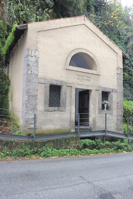
I studied these signs for a while hoping they would indicate where this site might be located. You can see in the photo below that a small chapel is hidden behind the signs. I recognized this from the Google Earth street view. It's hard to describe the surge of excitement that went through me when I realized I'd found the Tagliata.
I headed for the chapel and soon found the Roman pavers partially buried by the asphalt.
Early on in my explorations, I made a pact with myself that when I got to a section of ancient Roman road I would do two things; first I'd photograph myself standing on the pavers, then I would walk the road until it ended.
I haven't been able to find much information about this church other than the obvious; that it was built directly on top of the Ancient Road.
The road wound its way around the church and extended for another 100 yards. A nice railing had been installed, from which you could see the work that had been done on the other side of the road.
I tried to take a photograph over the railing to see what the stratigraphy was like under the pavers. Even with soil eroded from underneath them, clearly they had stayed lodged in place.
The wear marks were perfect, intact and untouched.
Eventually the road made a slight turn, at which point the pavers ended and a modern path started. They began again about 100 ft from this point near the Ponte Amato.
On my return route, I walked below the Roman road on the new road. For Italians, the idea of creating a shoulder much wider that a foot or so is extreme. I spent much of the short walk pressed up against the tufa cliffs hoping that I wouldn't be castrated by a side mirror.
However, I was able to see how this road was built. Most Roman Roads are built on a significant foundation.
 |
| Source: http://en.wikipedia.org/wiki/File:Via_Munita.png |
Directions
View Tagliata di Santa Maria Cavamonte in a larger map


No comments:
Post a Comment